Piła County
County in Greater Poland Voivodeship, PolandPiła County is a unit of territorial administration and local government (powiat) in Greater Poland Voivodeship, west-central Poland. It came into being on January 1, 1999, as a result of the Polish local government reforms passed in 1998. Its administrative seat and largest town is Piła, which lies 85 kilometres (53 mi) north of the regional capital Poznań. The county contains four other towns: Wyrzysk, 36 km (22 mi) east of Piła, Ujście, 10 km (6 mi) south of Piła, Łobżenica, 37 km (23 mi) east of Piła, and Wysoka, 25 km (16 mi) east of Piła.
Read article


Top Questions
AI generatedMore questions
Nearby Places

Piła Voivodeship
Former administrative division of Poland (1975–1998)

Piła
Place in Greater Poland Voivodeship, Poland

Okrąglak roundhouse in Piła
Cyk, Greater Poland Voivodeship
Village in Greater Poland Voivodeship, Poland
Dolaszewo
Village in Greater Poland Voivodeship, Poland
Byszki
Village in Greater Poland Voivodeship, Poland

Ługi Ujskie
Village in Greater Poland Voivodeship, Poland
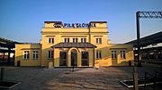
Piła Główna railway station
Railway station in Piła, Poland